 Urban Sprawl - the blob that ate Phoenix
The growth of the Phoenix metropolitan area is out of control. Every year thousands of acres of farm land and Sonoran desert are turned into suburban housing developments, strip malls and parking lots. For those of us who can remember the Valley of the Sun as it was 50 years ago, or even 20 years ago, the town is unrecognizable.
Phoenix is now the 6th largest metropolitan area in the US and it has been running neck to neck with Las Vegas for three decades as the fastest growing city in America. The Metropolitan Phoenix area is located in Maricopa County, which itself covers an area of 9,226 square miles. To put this is simple terms, The Phoenix metropolitan area has a population greater than 17 states: Alaska, Delaware, Hawaii, Idaho, Maine, Montana, Nebraska, Nevada, New Hampshire, New Mexico, North Dakota, Rhode Island, South Dakota, Utah, Vermont, West Virginia, and Wyoming.
Consider also that Maricopa County's 9,226 square miles make it geographically larger than the states of Connecticut, Delaware, Hawaii, New Hampshire, New Jersey, Massachusetts, and Rhode Island. That is big!
Urban Sprawl - the blob that ate Phoenix
The growth of the Phoenix metropolitan area is out of control. Every year thousands of acres of farm land and Sonoran desert are turned into suburban housing developments, strip malls and parking lots. For those of us who can remember the Valley of the Sun as it was 50 years ago, or even 20 years ago, the town is unrecognizable.
Phoenix is now the 6th largest metropolitan area in the US and it has been running neck to neck with Las Vegas for three decades as the fastest growing city in America. The Metropolitan Phoenix area is located in Maricopa County, which itself covers an area of 9,226 square miles. To put this is simple terms, The Phoenix metropolitan area has a population greater than 17 states: Alaska, Delaware, Hawaii, Idaho, Maine, Montana, Nebraska, Nevada, New Hampshire, New Mexico, North Dakota, Rhode Island, South Dakota, Utah, Vermont, West Virginia, and Wyoming.
Consider also that Maricopa County's 9,226 square miles make it geographically larger than the states of Connecticut, Delaware, Hawaii, New Hampshire, New Jersey, Massachusetts, and Rhode Island. That is big!
About this page...
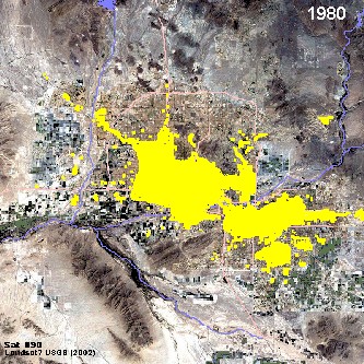
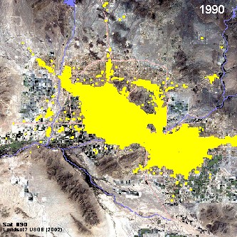
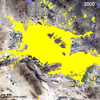
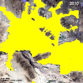
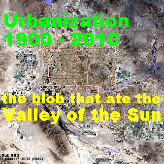
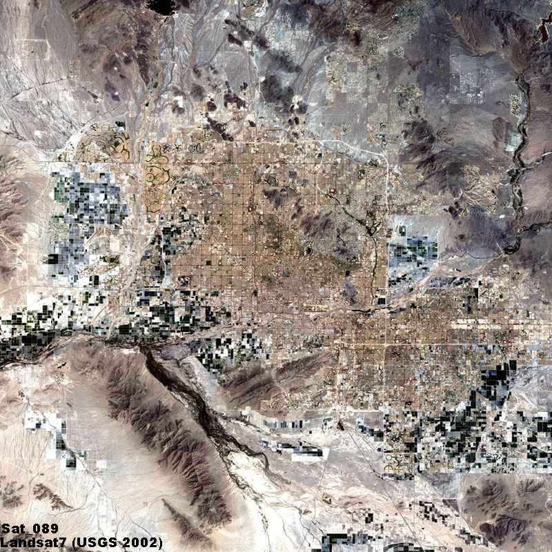
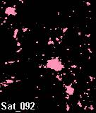
 The reason for this page is that I wanted to show how much Phoenix has grown. I tried several formats before coming up with the animated "gif" image above. I made it based upon maps I have that cover several decades as well as 50 plus years personal experience. It ain't perfect, but its pretty darn good for an amateur. I started with one of the 100 or so satellite pictures of Arizona that I have collected over 10 years (see icon at left), and added, decade by decade, the approximate urban perimeter for the different cities in the Valley of the Sun. It was quite easy until 1960, then they began to merge as they grew together. The image is from www.earthobservatory.nasa.gov and was taken by Landsat7 in 5/2002.
By the 1990s, I found it almost impossible to figure out where the cities ended and the country side began. It had become one big blob, like a cancer spreading out through the organism.
The reason for this page is that I wanted to show how much Phoenix has grown. I tried several formats before coming up with the animated "gif" image above. I made it based upon maps I have that cover several decades as well as 50 plus years personal experience. It ain't perfect, but its pretty darn good for an amateur. I started with one of the 100 or so satellite pictures of Arizona that I have collected over 10 years (see icon at left), and added, decade by decade, the approximate urban perimeter for the different cities in the Valley of the Sun. It was quite easy until 1960, then they began to merge as they grew together. The image is from www.earthobservatory.nasa.gov and was taken by Landsat7 in 5/2002.
By the 1990s, I found it almost impossible to figure out where the cities ended and the country side began. It had become one big blob, like a cancer spreading out through the organism.

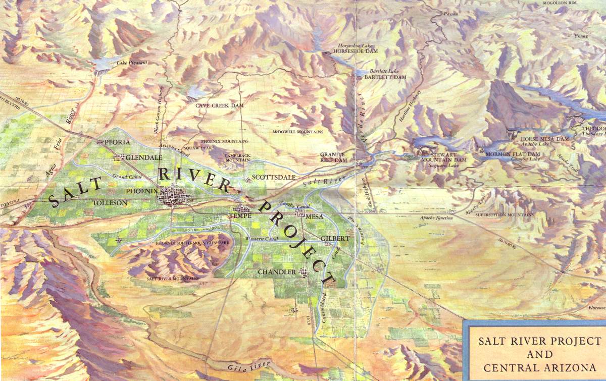
 This is a false color image of the Phoenix area. The light green areas are planted vegetation, or fields. By about 1920, the agricultural activities around Phoenix had reached their greatest extent, and changed little over the next 30 years. The many big canals had been built, and Arizona - and in particular Phoenix - was a major center for cotton, citrus and cattle. The entire Valley of the Sun was basically a few small scattered cities separed a few miles from each other, in the middle of a huge network of fields and orchards. Around the mountains and buttes in the Valley, and in the surrounding country side, was the desert. Initially the major cities grew slowly - Phoenix, Mesa, Tempe and Glendale - occupying farm lands at a very steady but slow pace. Even when I was young in the 1950s, the land below Broadway Road was cotton fields, Chandler was a drive down a rural two-lane highway (and watch out for cows) along corn fields, Tempe was almost 3 miles from Mesa and Phoenix didn't start until about 40th Street. I even remember hunting in the empty worthless land north of Camelback, a place now called "Paradise Valley." The second image here is a very common map showing the Valley of the Sun and the "Salt River Project" as it was for 50 years. This is the Phoenix of my childhood, with fields and orchards, small towns and rocky buttes, far mountains and endless sky - it was a quiet, friendly place, and it is long gone.
 This was my first attempt at showing urban growth.
It was in the 1950s that everything changed. The post-war baby boom had begun (including me!) and somebody invented air-conditioning. Arizona began to grow and it hasn't stopped since. Every year hundreds (now its thousands!) of acres of fields are sold to developers and turned into homes, offices, industries, service centers, markets, streets, schools - and still they come. By the 1980s developers began building subdivisions on what had been desert areas around town, particularly in the areas north of Scottsdale. Note: the thumbnail image displays a picture of urban growth in the Phoenix area by decade. After I did this project, I decided it was too cluttered and confusing, so I redid it and came up with the animated image above.
 Of course, after I had done my image, I came across one that had much of the same information, but was probably more precise and certainly more professional, as seen here. I think it was from the people at MAG (Maricopa Association of Governments). It shows land use in 1912, 1934, 1955, 1975 and 1995. Play special attention to the green areas - these designate land used for agriculture.
Lights and Luminosity

 Here are two other images that show urban growth in a different manner. The first shows luminosity patterns for major cities in the Southwestern part of the US. The image on the right is from the "Dark Skies" website, and shows how Arizona looks at night to satellites. The fact is that the Phoenix area is growing quickly, expanding in all directions. At the same time, Tucson is also growing. I figure, at the current rate, and considering the growth of the Casa Grande area to the south, the two luminosity signatures of Phoenix and Tucson will link up by 2020. So the blob that ate Phoenix and the Valley of the Sun will become the blob that ate all of Central and Southeastern Arizona. Who would have thought!

 Talk about hot!
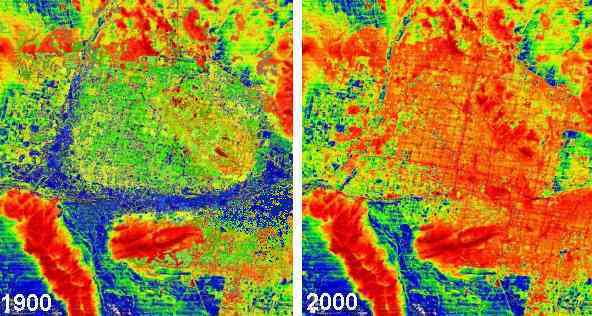
I am only putting this image here because it is one of my favorites. It shows heat patterns for Central Arizona. Red is hot and blue is not. Notice how the Estrella Mountains stick out. Strangely, as I understand it, the desert lowland areas (mostly blue) are cooler that the fields (green), which are themselves cooler than the built-up urban areas (orange and red). The hottest areas are the sides of the mountains (dark brownish red) particularly the rock on the Estrellas and the South Mountains.
I have added a second thumbnail showing the possible differences between the image taken in 2000 and the one that shows how it may have looked in about 1900. The fact is that pavement and cement stores and radiates as much heat as the granite in the mountains. Other constructions - buildings and roofs particularly - are hotter than desert areas. Worst of all are metal objects, like cars. I am guessing that one car will absorb and hold as much heat as an acre of land. This may be why it seems that Phoenix is getting warmer every year!
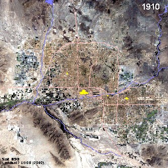
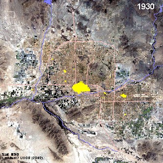
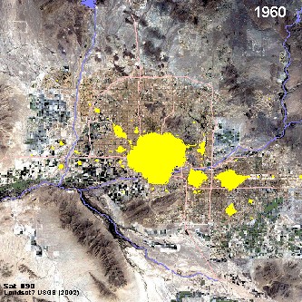
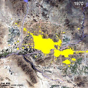
Last of all, I am including here the images for each decade that I used to make the 'animated blob' sequence above. As I said, the growth patterns and urban limits for the first several decades were fairly easy to follow. It was after the 1960s that I had a real problem determining where the city ended and the countryside began. How many houses in a area does it take to consider it part of the city? The street maps weren't much help. Anyway, to a certain extent, any representation of this nature is arbitrary. I did my best! Here are the 12 images:


It never ends...
 Developer buys 1,010 acres of trust land
http://www.azcentral.com/arizonarepublic/local/articles/1208superauction1208.html
Carl Holcombe and Lars Jacoby
The Arizona Republic
Dec. 8, 2006 12:00 AM
The auction Thursday of 1,010 acres in Pinal County destroyed the notion that developers' appetite for state trust land had waned in a cooling real estate market and kicked off the future of the southeast Valley.
The auctioned land is in the Lost Dutchman Heights area, part of a 275-square-mile swath of state land between Apache Junction and Florence called Superstition Vistas.
At build-out, Superstition Vistas is expected to be home to a million people and will nearly double the size of the southeast Valley.
Desert Communities Inc., an affiliate of Las Vegas-based Rhodes Homes, beat out Denver-based Actus Lend Lease LLC with a final bid of $58.6 million.
"That's a great price for that view of the Supes (Superstition Mountains)," said Apache Junction Councilman Kris Sippel
It's the gateway to the future out here in this area," said Jim Rhodes, president and CEO of Rhodes Homes. The win also locks Desert Communities into master planning the entire 7,000-acre Lost Dutchman area, all of which is within Apache Junction city limits.
"(This) certainly was one of the highlights of the year and a good way too close out the year," said Land Commissioner Mark Winkleman.
City and state officials see the master-planning requirement as a way to encourage smarter planning and reduce the impact of rapid growth and sprawl
We're excited. We're thrilled," said Apache Junction City Manager George Hoffman. "There has been a lot of work with the State Land Department to get to this point."
The city has hired a new planner with large-scale development experience to work with the state and Desert Communities, Hoffman said.
Master planning will include plotting locations for roads, infrastructure, job centers and utilities in an attempt to avoid problems that have plagued other fast-growing Valley areas
Desert Communities will pay 10 percent down and finance the rest of the deal with the state over seven years, State Land Department officials said.
Future auctions will determine who develops the rest of Lost Dutchman and Superstition Vistas.
Developer buys 1,010 acres of trust land
http://www.azcentral.com/arizonarepublic/local/articles/1208superauction1208.html
Carl Holcombe and Lars Jacoby
The Arizona Republic
Dec. 8, 2006 12:00 AM
The auction Thursday of 1,010 acres in Pinal County destroyed the notion that developers' appetite for state trust land had waned in a cooling real estate market and kicked off the future of the southeast Valley.
The auctioned land is in the Lost Dutchman Heights area, part of a 275-square-mile swath of state land between Apache Junction and Florence called Superstition Vistas.
At build-out, Superstition Vistas is expected to be home to a million people and will nearly double the size of the southeast Valley.
Desert Communities Inc., an affiliate of Las Vegas-based Rhodes Homes, beat out Denver-based Actus Lend Lease LLC with a final bid of $58.6 million.
"That's a great price for that view of the Supes (Superstition Mountains)," said Apache Junction Councilman Kris Sippel
It's the gateway to the future out here in this area," said Jim Rhodes, president and CEO of Rhodes Homes. The win also locks Desert Communities into master planning the entire 7,000-acre Lost Dutchman area, all of which is within Apache Junction city limits.
"(This) certainly was one of the highlights of the year and a good way too close out the year," said Land Commissioner Mark Winkleman.
City and state officials see the master-planning requirement as a way to encourage smarter planning and reduce the impact of rapid growth and sprawl
We're excited. We're thrilled," said Apache Junction City Manager George Hoffman. "There has been a lot of work with the State Land Department to get to this point."
The city has hired a new planner with large-scale development experience to work with the state and Desert Communities, Hoffman said.
Master planning will include plotting locations for roads, infrastructure, job centers and utilities in an attempt to avoid problems that have plagued other fast-growing Valley areas
Desert Communities will pay 10 percent down and finance the rest of the deal with the state over seven years, State Land Department officials said.
Future auctions will determine who develops the rest of Lost Dutchman and Superstition Vistas.


Arizona leads pack in adding residents (By Stephen Ohlemacher, Associated Press, December 22, 2006
WASHINGTON -- Arizona has ended Nevada's 19-year reign as the nation's fastest-growing state, fueled by immigrants and Americans moving from other states.
Arizona led the nation with a population growth rate of 3.6 percent in the past year, followed by Nevada, Idaho, Georgia and Texas.
"There are housing developments sprouting everywhere, whether they are on former farmland or in the desert," said Tom Rex, associate director of the Center for Competitiveness and Prosperity Research at Arizona State University.
The pace of development has strained Arizona's resources and preoccupied local officials, he said.
"All they can think about is getting the sewer lines out to the new housing and getting the roads in," Rex said.

 The reason for this page is that I wanted to show how much Phoenix has grown. I tried several formats before coming up with the animated "gif" image above. I made it based upon maps I have that cover several decades as well as 50 plus years personal experience. It ain't perfect, but its pretty darn good for an amateur. I started with one of the 100 or so satellite pictures of Arizona that I have collected over 10 years (see icon at left), and added, decade by decade, the approximate urban perimeter for the different cities in the Valley of the Sun. It was quite easy until 1960, then they began to merge as they grew together. The image is from www.earthobservatory.nasa.gov and was taken by Landsat7 in 5/2002.
By the 1990s, I found it almost impossible to figure out where the cities ended and the country side began. It had become one big blob, like a cancer spreading out through the organism.
The reason for this page is that I wanted to show how much Phoenix has grown. I tried several formats before coming up with the animated "gif" image above. I made it based upon maps I have that cover several decades as well as 50 plus years personal experience. It ain't perfect, but its pretty darn good for an amateur. I started with one of the 100 or so satellite pictures of Arizona that I have collected over 10 years (see icon at left), and added, decade by decade, the approximate urban perimeter for the different cities in the Valley of the Sun. It was quite easy until 1960, then they began to merge as they grew together. The image is from www.earthobservatory.nasa.gov and was taken by Landsat7 in 5/2002.
By the 1990s, I found it almost impossible to figure out where the cities ended and the country side began. It had become one big blob, like a cancer spreading out through the organism.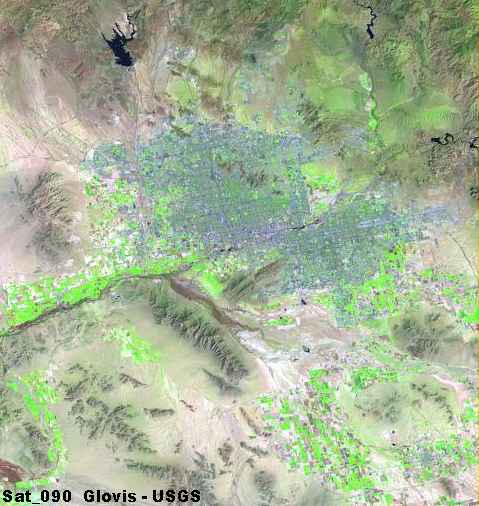
 This is a false color image of the Phoenix area. The light green areas are planted vegetation, or fields. By about 1920, the agricultural activities around Phoenix had reached their greatest extent, and changed little over the next 30 years. The many big canals had been built, and Arizona - and in particular Phoenix - was a major center for cotton, citrus and cattle. The entire Valley of the Sun was basically a few small scattered cities separed a few miles from each other, in the middle of a huge network of fields and orchards. Around the mountains and buttes in the Valley, and in the surrounding country side, was the desert. Initially the major cities grew slowly - Phoenix, Mesa, Tempe and Glendale - occupying farm lands at a very steady but slow pace. Even when I was young in the 1950s, the land below Broadway Road was cotton fields, Chandler was a drive down a rural two-lane highway (and watch out for cows) along corn fields, Tempe was almost 3 miles from Mesa and Phoenix didn't start until about 40th Street. I even remember hunting in the empty worthless land north of Camelback, a place now called "Paradise Valley." The second image here is a very common map showing the Valley of the Sun and the "Salt River Project" as it was for 50 years. This is the Phoenix of my childhood, with fields and orchards, small towns and rocky buttes, far mountains and endless sky - it was a quiet, friendly place, and it is long gone.
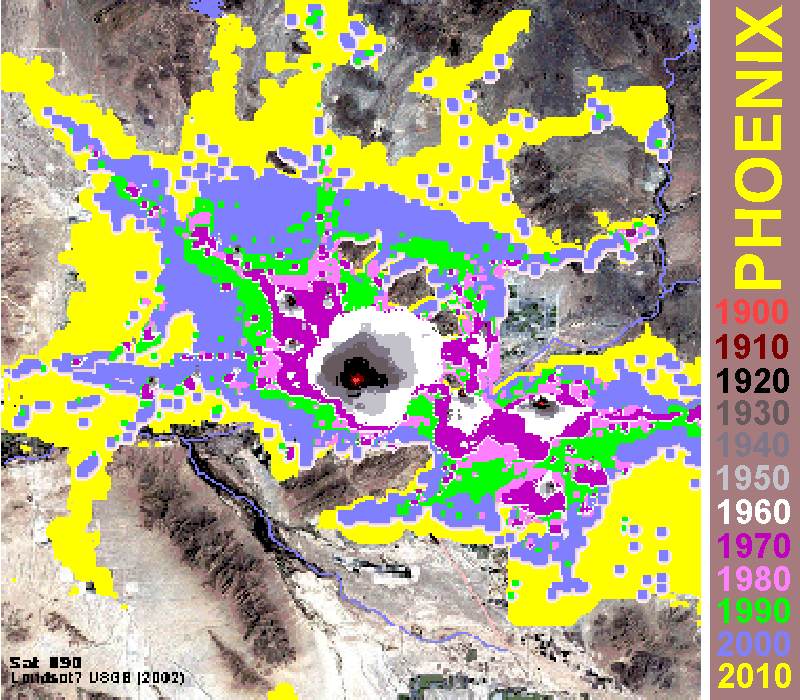 This was my first attempt at showing urban growth.
 Of course, after I had done my image, I came across one that had much of the same information, but was probably more precise and certainly more professional, as seen here. I think it was from the people at MAG (Maricopa Association of Governments). It shows land use in 1912, 1934, 1955, 1975 and 1995. Play special attention to the green areas - these designate land used for agriculture.
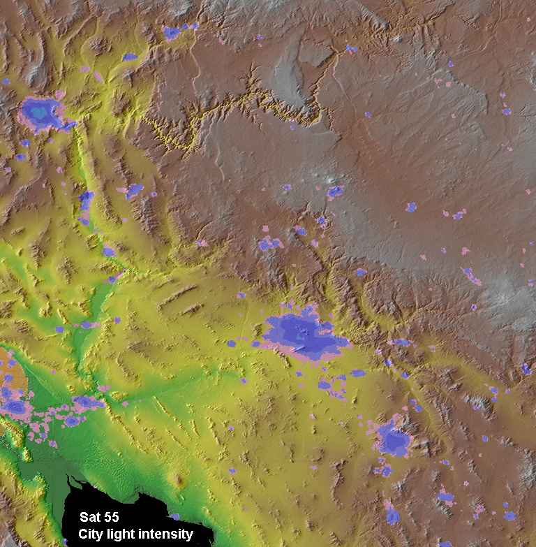
 Here are two other images that show urban growth in a different manner. The first shows luminosity patterns for major cities in the Southwestern part of the US. The image on the right is from the "Dark Skies" website, and shows how Arizona looks at night to satellites. The fact is that the Phoenix area is growing quickly, expanding in all directions. At the same time, Tucson is also growing. I figure, at the current rate, and considering the growth of the Casa Grande area to the south, the two luminosity signatures of Phoenix and Tucson will link up by 2020. So the blob that ate Phoenix and the Valley of the Sun will become the blob that ate all of Central and Southeastern Arizona. Who would have thought!
 Talk about hot!