
|
|
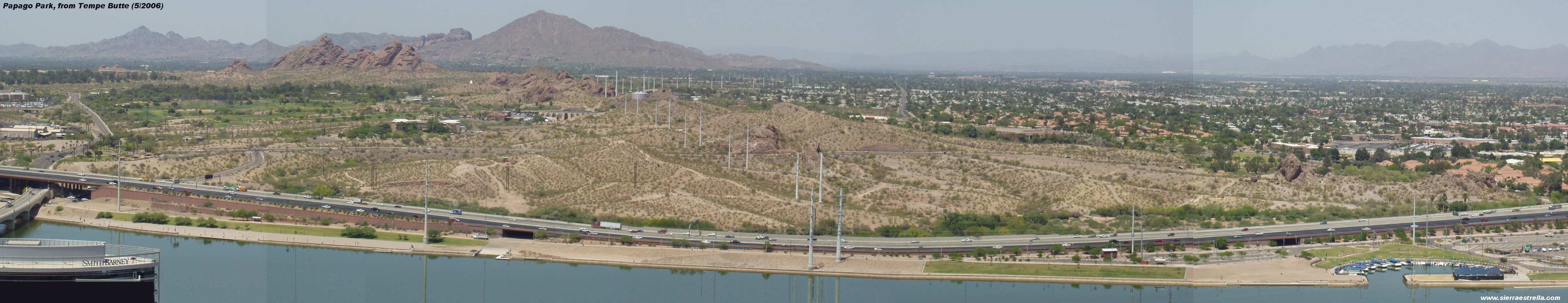
 The Valley of the Sun - all of it! Click on the image here to see the full 360 degree picture taken from a hill on Papago Park. Warning: it is BIG! About 6666 x 500 pixels.
A quick word about the little symbols on the page: this
The Valley of the Sun - all of it! Click on the image here to see the full 360 degree picture taken from a hill on Papago Park. Warning: it is BIG! About 6666 x 500 pixels.
A quick word about the little symbols on the page: this  means a picture is available and this
  is a link to another page.
This page is an attempt to show the entire extent of the Valley of the Sun, as the Greater Phoenix area is known. In early 2003 I went down to Papago Park a couple of blocks away and climbed the two buttes on the south side of McDowell. The object of this exercise was to obtain a clear 360 degree view of the Valley of the Sun and all the surrounding hills, buttes and mountain ranges. I took a series of pictures and put them together, as seen in the image on the left. Warning: this page started off as a description of the mountain ranges in the Phoenix area, but somehow ended up as a page about the sorry politics of the City of Tempe. I apologize, but I'll leave it here anyway.
To me, the expression "Valley of the Sun" is misleading. The Valley is not really a valley, but a plain somewhat surrounded by isolated mountains and buttes. A valley is supposed to have slopping sides, isn't it? Anyway, "Valley of the Sun" sounds a lot better than "Plain of the Sun"... Also, the Phoenix area used to be located in the "Salt River valley" up until the 1930s, when some real-estate people and politicians decided that "Valley of the Sun" had a better ring to it. Clever PR move, that!
is a link to another page.
This page is an attempt to show the entire extent of the Valley of the Sun, as the Greater Phoenix area is known. In early 2003 I went down to Papago Park a couple of blocks away and climbed the two buttes on the south side of McDowell. The object of this exercise was to obtain a clear 360 degree view of the Valley of the Sun and all the surrounding hills, buttes and mountain ranges. I took a series of pictures and put them together, as seen in the image on the left. Warning: this page started off as a description of the mountain ranges in the Phoenix area, but somehow ended up as a page about the sorry politics of the City of Tempe. I apologize, but I'll leave it here anyway.
To me, the expression "Valley of the Sun" is misleading. The Valley is not really a valley, but a plain somewhat surrounded by isolated mountains and buttes. A valley is supposed to have slopping sides, isn't it? Anyway, "Valley of the Sun" sounds a lot better than "Plain of the Sun"... Also, the Phoenix area used to be located in the "Salt River valley" up until the 1930s, when some real-estate people and politicians decided that "Valley of the Sun" had a better ring to it. Clever PR move, that!
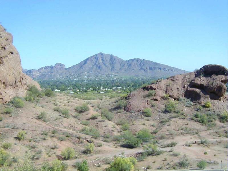
 . I found it interesting that Camelback is so much like a camel that it could only have that name, yet the first reference to that designation was occurs only in the early 20th century, about 1903 I believe. How that particular mountain and its shape escaped notice for 30 years I have no idea. And you can't blame the Indians on that - they had never seen a camel (Well, only the other hand, there were camels in territorial Arizona, but that's another story).
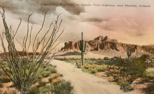 , home of the Lost Dutchman Legend - the world's most famous Lost Treasure. That is maybe why you run across comics books in Portuguese, from Brazil, that have stories about Donald Duck (Pato Donald), the Montanhas Supersticao, Velho Peralta (Old man Peralta) and the Holandez and his ouro (gold)
 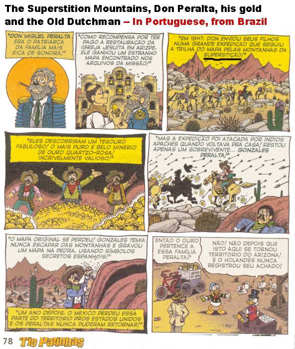 . I highly recommend a trip out to the Superstitions and up the Apache Trail on the north side. It is still wild and very scenic, and be sure to stop at Tortilla Flats
  , a small store that has been there forever. A word of warning: the Apache Trail is unpaved (after Tortilla flats), narrow and crooked. Also the fact that some of it runs along the side of a cliff with a 300 foot drop on one side should also be taken into account. My wife also kept asking about all the little white crosses along the side of the road, too. If you are lucky, as we were, you will meet a houseboat trailer on a curve and will have the joy of slowly backing up around a curve over a precipice to let the boat pass. Oh yes, there is a group of folks that believe the Superstitions are home to the "Lizard People" from Outer Space, of course, as in this picture of the Internet site:
 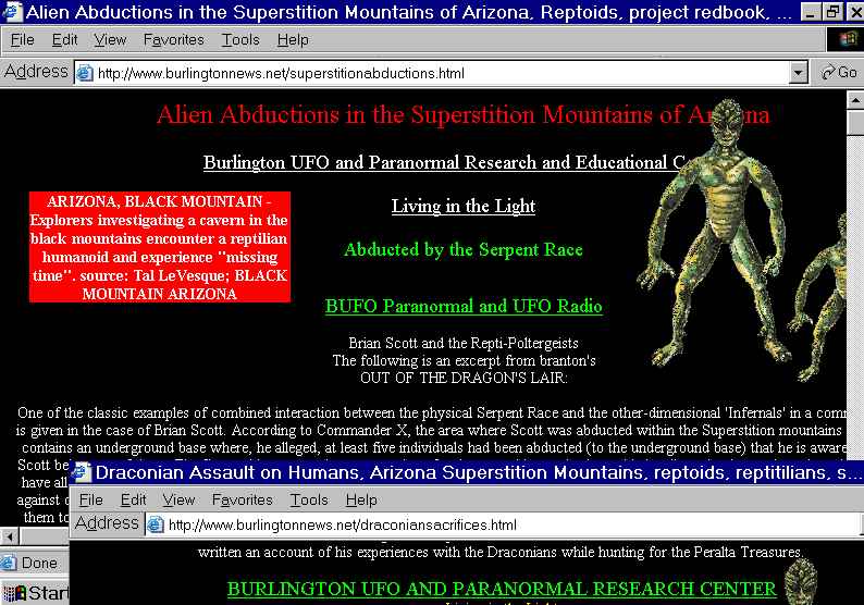 . Once again I swear I am not making this up!

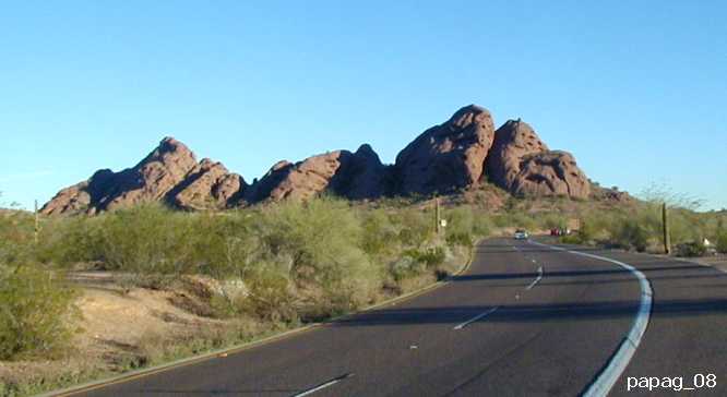
 Three more "panoramic" views of the Park.
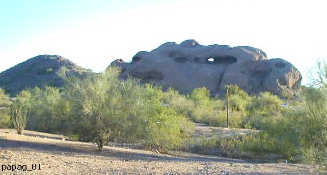
 . As a kid I always enjoyed the climb and going through the hole. The sides of the rock are an easy climb, for the most part. However, appearances are deceiving and a gentle angle can turn into a somewhat dangerous situation. Once in a while a climber is hurt or killed on the rock. Careful! Oh yes, there is a theory that the Valley of the Sun and the Indian ruins around the Phoenix area was the site of the Seven Cities of Cebola (Coronado's Seven Cities of Gold). Here are a few pages from the book:
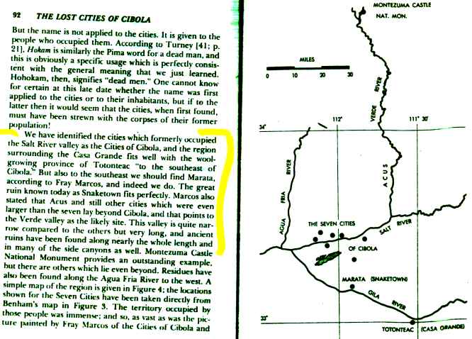
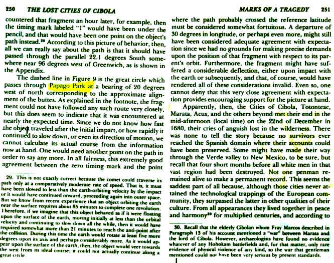 . According to this somewhat mad author, the mud-like, unique and strange rock formations in Papago Park are the result of a large meteor that hit what is now Papago Park at 3:05 PM on December 22, 1680, destroying the 7 Golden Cities and wiping out the Hohokam civilization in the Phoenix area. It was a very bad Christmas for the Indians.
I am not making this up! If you visit the Phoenix, a visit to Papago Park is a must. The Zoo and the Botanical gardens are in the Park area. Although long gone, Papago Park was the site of the Famous POW camp in World War II, a place that was a mixture of Hogan's Heroes, Camp Comedy and Yuma Prison
. According to this somewhat mad author, the mud-like, unique and strange rock formations in Papago Park are the result of a large meteor that hit what is now Papago Park at 3:05 PM on December 22, 1680, destroying the 7 Golden Cities and wiping out the Hohokam civilization in the Phoenix area. It was a very bad Christmas for the Indians.
I am not making this up! If you visit the Phoenix, a visit to Papago Park is a must. The Zoo and the Botanical gardens are in the Park area. Although long gone, Papago Park was the site of the Famous POW camp in World War II, a place that was a mixture of Hogan's Heroes, Camp Comedy and Yuma Prison 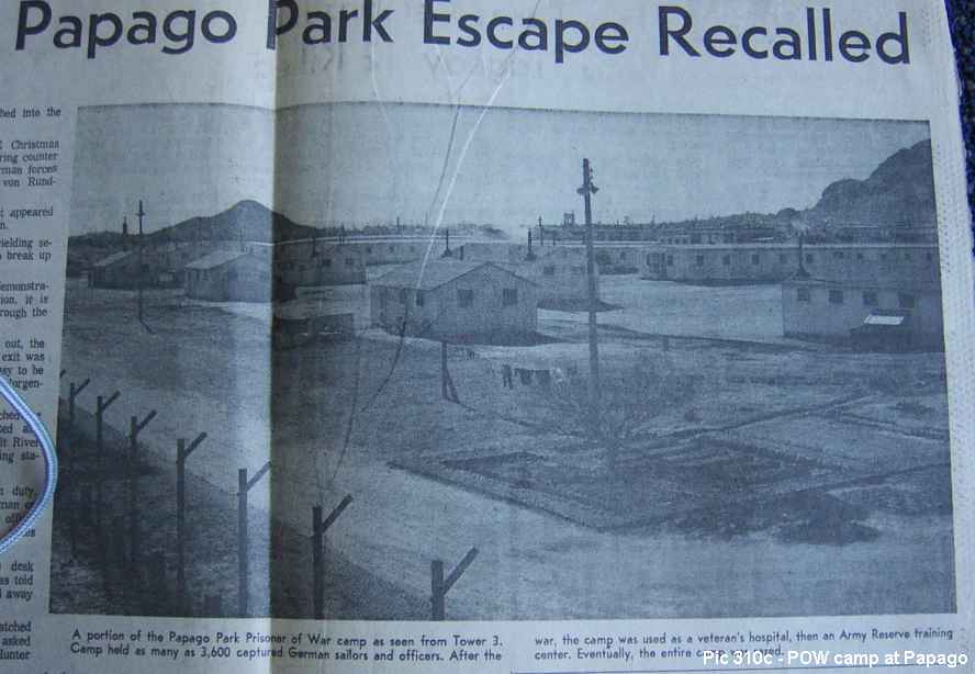
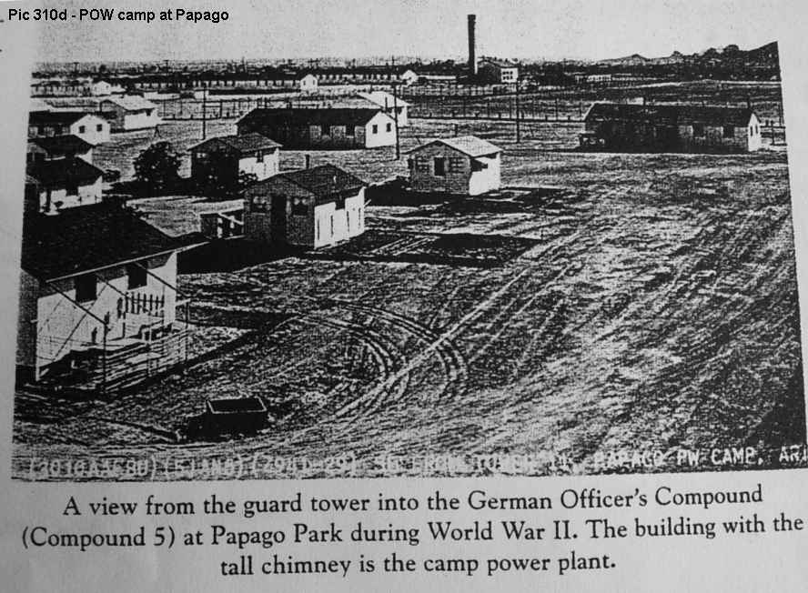 . The camp was the site of the most famous POW escape in US history, with all the elements of drama and comedy. There are stories that the German soldiers even had local girlfriends. The camp was also the site of the execution of a spy by the Germans, leading to the subsequent trail, conviction and mass execution of prisoners by the US government. Oh yes, the Papago Park area is also where I live, and the best neighborbood in all of the Valley
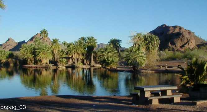
 .
This is a cool link to a satellite image map of the Papago Park area from Google:
.
This is a cool link to a satellite image map of the Papago Park area from Google:  . You can move the scroll and move the map with your mouse (hold down the mouse button) and well as zoom in and out. The map link is centered on the Hold-in-the-Rock hill
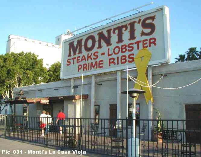
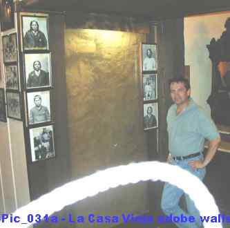 , it too is worth a visit. At the bottom of this page you will find a few comments on Tempe, the Butte and even the famous 'A' on the south side of the Butte. Maybe you can get Michael to give you the Grand Tour of 'the Old House', and check out the 3-foot thick walls. Also ask about the "Passion Pit". Everybody at Monti's knows the Passion Pit.
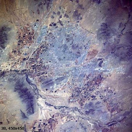
 Here is another view of the mountains in the Phoenix Area, from space. The image is centered on the crossroads of Central Avenue and Washington in downtown Phoenix, which is, of course, the zero point for North/South and East/West coordinates for Phoenix and many of the cities (but not all!) in the Valley of the Sun. I have added circles to indicate 5 miles radius lines, up to a distance of more than 25 miles from the central point. City and/or community names are in yellow, and mountains and main landmarks are in white letters. As you can see, Phoenix and company is a very squared city, with major roadway arteries running north and south or east and west every mile, mile after mile. This, with the very flat nature of most of the landscape, the uniform street numbering system, the mountains around, make Phoenix and the valley one of the easiest metropolitan areas in the world to understand - even men cannot get lost. The long roads at the mile mark also mean that some of the roads in the Valley of the Sun are about the longest in the world: for example, for example: Southern Avenue from East to West, is probably about 80 miles long, and pretty much in a straight line. One last thing. As a curiosity, on this image one can see the markings of the first and only remaining pioneer landmark in the Valley from over 150 years ago, under the '20 miles' label at the bottom of the picture. This is what is left of historic Maricopa Wells
 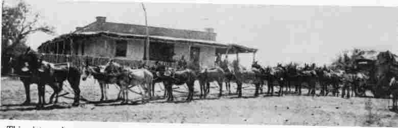 and you can read about it here: .
 and
and  . The surviving Mohaves and Yumans escaped to hide in the Estrellas, and only a few made it back to the Colorado River. For a change, the whites (anglos, gringos) that witnessed the battle from Maricopa Wells, did not get involved. The bodies of the fallen were visible for years afterwards. Pima Butte appears twice in the photo because the pictures were taken from two different hills in Papago Park.
. When I was young the area was best known as the location of the Japanese Flower Gardens, where miles and miles of flowers were planted along Baseline Road by Japanese immigrants
. The surviving Mohaves and Yumans escaped to hide in the Estrellas, and only a few made it back to the Colorado River. For a change, the whites (anglos, gringos) that witnessed the battle from Maricopa Wells, did not get involved. The bodies of the fallen were visible for years afterwards. Pima Butte appears twice in the photo because the pictures were taken from two different hills in Papago Park.
. When I was young the area was best known as the location of the Japanese Flower Gardens, where miles and miles of flowers were planted along Baseline Road by Japanese immigrants 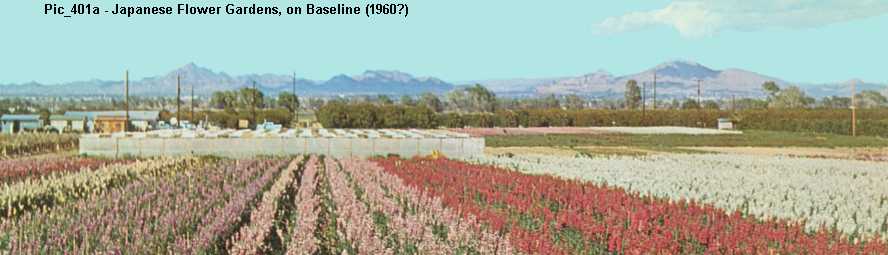 . They are pretty much all gone now, replaced by homes and apartments.
 in Central Arizona. Anyway the Sierra de las Estrellas have it all: pioneers, massacres, Indian warrior legends, mines, lost treasures, UFOs, and even monsters (


 ). There are no Lizard Men in the Estrellas, I guess they don't get along with the Chupacabras (Those goat-sucker fellows can be really unpleasant!). Enough! I'll let it go at that - you can find out more about the "Mountains of the Stars" somewhere on this site.
 that were making a ruckus in my backyard (and they said I couldn't take great photos). Of courses, living in the desert has its drawbacks, as seen here:
  . Ouch, that hurt! Ever since I was a kid I have hated cholla! They are the meanest cactus around. This is why my Dad used to carry pliers with him when we went out to the Estrellas, way back when.


 . Before the big U of A / ASU football game, there are usually some stupid students that stay up and freeze all night while "guarding" the "A" from enemy paint jobs. Go figure. Since ASU took Tempe Butte for their "A", the local Tempe High School had to go use the Twin Buttes (or sometimes Double Buttes) to paint their big "T" .
Here is a link to a satellite image of the "A" on Tempe Butte, Google Maps: . You can scroll and move the map with your mouse (hold down the mouse button) and well as zoom in and out. The map link is centered on Tempe Butte and the two water tanks on it. You can move the image around to see the Rio Salado river area and downtown Tempe.
Arizona has changed and painting big letters on the sides of hills is frowned upon and considered a desecration of nature, so the tradition of painting school letters on local desert hills is fading away, like the letters themselves.
Oh yes, one more thing about ASU and U of A... I remember in the 50s, when ASC became a university, the University of Arizona fought hard to prevent it
. Before the big U of A / ASU football game, there are usually some stupid students that stay up and freeze all night while "guarding" the "A" from enemy paint jobs. Go figure. Since ASU took Tempe Butte for their "A", the local Tempe High School had to go use the Twin Buttes (or sometimes Double Buttes) to paint their big "T" .
Here is a link to a satellite image of the "A" on Tempe Butte, Google Maps: . You can scroll and move the map with your mouse (hold down the mouse button) and well as zoom in and out. The map link is centered on Tempe Butte and the two water tanks on it. You can move the image around to see the Rio Salado river area and downtown Tempe.
Arizona has changed and painting big letters on the sides of hills is frowned upon and considered a desecration of nature, so the tradition of painting school letters on local desert hills is fading away, like the letters themselves.
Oh yes, one more thing about ASU and U of A... I remember in the 50s, when ASC became a university, the University of Arizona fought hard to prevent it  . There was never any love lost between the two universities: when I was a boy the Sun Devils (as the ASU team is known) could lose every game of the season, but if they won the big game against the Wildcats (as U of A is known) it was considered a good year!
And there was the parking meter controversy. A few years ago (about 2000?) some genius at the City of Tempe government decided that people were taking advantage of the fact that un-expired time on vacated parking meters was being used by other people to park for free (oh horror!) and thus depriving the City government of a few nickels each day per meter. So what did they do, they got rid of the traditional parking meters along the curbs, that had been used for decades, and put in a more modern system that used numbered spaces and centralized collection points. It was a disaster - not user friendly at all. The new system required a person who wanted to park to note the space number, go to a centralized computerized meter box up to 50 yards away, hope it was the right meter for that space, input the space number, pay, receive a ticket with a time stamp, and hope the machine wasn't out of paper or screwed up. Of course, since there was no individual meter or visible time-remaining indicator, a person parking would not know if there was any free time left, so, in theory, the City not only saved on labor collection costs, but also would thwart those uncivil folks that did not pay for a few minutes of left-over free meter time. The citizens of Tempe hated it! Well, the meters were bad, but it gets worse. The Government of Tempe was so alert and in tune with the people and local traditions that it did not even notice that all the new fancy computerized meters and signs for the new system -- all over downtown Tempe -- were painted in bright blue and red, the colors of hated arch-rival University of Arizona. A case of insult added to injury. The old parking meters are back!
. There was never any love lost between the two universities: when I was a boy the Sun Devils (as the ASU team is known) could lose every game of the season, but if they won the big game against the Wildcats (as U of A is known) it was considered a good year!
And there was the parking meter controversy. A few years ago (about 2000?) some genius at the City of Tempe government decided that people were taking advantage of the fact that un-expired time on vacated parking meters was being used by other people to park for free (oh horror!) and thus depriving the City government of a few nickels each day per meter. So what did they do, they got rid of the traditional parking meters along the curbs, that had been used for decades, and put in a more modern system that used numbered spaces and centralized collection points. It was a disaster - not user friendly at all. The new system required a person who wanted to park to note the space number, go to a centralized computerized meter box up to 50 yards away, hope it was the right meter for that space, input the space number, pay, receive a ticket with a time stamp, and hope the machine wasn't out of paper or screwed up. Of course, since there was no individual meter or visible time-remaining indicator, a person parking would not know if there was any free time left, so, in theory, the City not only saved on labor collection costs, but also would thwart those uncivil folks that did not pay for a few minutes of left-over free meter time. The citizens of Tempe hated it! Well, the meters were bad, but it gets worse. The Government of Tempe was so alert and in tune with the people and local traditions that it did not even notice that all the new fancy computerized meters and signs for the new system -- all over downtown Tempe -- were painted in bright blue and red, the colors of hated arch-rival University of Arizona. A case of insult added to injury. The old parking meters are back!
 ) on Fifth Street are in the process of expropriating some private land to give it to another group of private owners, for the good of all humanity, of course. Not that this is anything new; these are the people that have given away millions of dollars to their pet contractors (ie, Brickyard, Rio Salado, etc...) on failed projects, and without even an 'oops'. The City of Tempe is easily the most Politically Correct town in Arizona, which would be fine if being PC meant being Polite and Considerate. The fact is that the Government of Tempe is probably the most discriminatory organization in the Valley of the Sun, with a record of abuse and favoritism that would embarrass anybody else (read the 'audit report' here: ). Remember, these are the people that used to empty the water from Tempe Beach (a public pool, long gone
  ) after 'Mexican' day (Fridays), so not to contaminate whites, I guess. We are still waiting for an apology on that one. Somebody should tell the Tempe officials that the purpose of government is to provide specific basic services to all, hopefully in a fair and equitable manner, instead of blindly promoting pseudo-intellectual fads with cute names / words like "diversity", "multiculturalism" and "inclusiveness" -- which by official city policy must be used at least once per paragraph in all city documents and communications, and when used, must also be acompanied by one of the following words: celebrate, proactive and awareness. This is why I resigned from the Human Race and joined the folks from Planet Cynicuss (the lizard people wouldn't have me!).
The fact is that the city government in Tempe has chosen to take perfectly good ideas like "diversity", "respect", "tolerance" and "inclusiveness" and turn them into a political dogma that has very little to do with real diversity, genuine respect, true tolerance and equality, and actual inclusiveness, and everything to do with a political and social agenda, with different standards for different people and groups (This is used to be called hypocrisy, now it is called Political Correctness). This would be OK for a lobby group or a non-profit, as far as I am concerned, but should be anathema to a local government that is supposed to exist to provide efficient, cost-effective services to all, not indoctrinate people, saying one thing and doing another, a la Animal Farm. I had better stop here. Maybe I would be kinder if I had one of those "required sensitivity training" courses the City of Tempe mentions on its website
) after 'Mexican' day (Fridays), so not to contaminate whites, I guess. We are still waiting for an apology on that one. Somebody should tell the Tempe officials that the purpose of government is to provide specific basic services to all, hopefully in a fair and equitable manner, instead of blindly promoting pseudo-intellectual fads with cute names / words like "diversity", "multiculturalism" and "inclusiveness" -- which by official city policy must be used at least once per paragraph in all city documents and communications, and when used, must also be acompanied by one of the following words: celebrate, proactive and awareness. This is why I resigned from the Human Race and joined the folks from Planet Cynicuss (the lizard people wouldn't have me!).
The fact is that the city government in Tempe has chosen to take perfectly good ideas like "diversity", "respect", "tolerance" and "inclusiveness" and turn them into a political dogma that has very little to do with real diversity, genuine respect, true tolerance and equality, and actual inclusiveness, and everything to do with a political and social agenda, with different standards for different people and groups (This is used to be called hypocrisy, now it is called Political Correctness). This would be OK for a lobby group or a non-profit, as far as I am concerned, but should be anathema to a local government that is supposed to exist to provide efficient, cost-effective services to all, not indoctrinate people, saying one thing and doing another, a la Animal Farm. I had better stop here. Maybe I would be kinder if I had one of those "required sensitivity training" courses the City of Tempe mentions on its website  -- but then again, maybe not. Instead of going on and on about this, I'll just write a page about Tempe, so not to mix apples and oranges, mountains and politics, good and bad. I have a couple of other issues with the City of Tempe that really make me mad. One last thought and I'll end this somewhat mindless diatribe. Why the government of the City hasn't tried to change its name to Tempce I don't know. Or maybe they should paint the Old Bridge
  bright orange and declare themselves San Francisco by the Butte, or Butt, or whatever.... Orwell would have had a field day! I ramble.

 And here are two more wide-angle views taken at Papago Park. Enjoy!


|
Search string words: a. "City of Tempe" b. + diversity c. + multiculturalism d. + racism e. f. "Valley of the Sun" g. + mountains h. + Camelback i. + Estrella j. + panorama |
Google results 56,300 3,910 16 1 134,000 40,200 7,520 725 27 |
Yahoo results 82,400 1,380 11 3 199,000 29,300 1,710 234 11 |
MSN Search 26,788 1,996 10 2 120,165 15,731 3,148 645 10 |
|
Search string words: a. "City of Tempe" b. + diversity c. + multiculturalism d. + racism e. f. "Valley of the Sun" g. + mountains h. + Camelback i. + Estrella j. + panorama |
Google results 57,400 4,090 24 5 230,000 59,800 9,850 782 108 |
Yahoo results 91,100 1,970 11 (1) 3 (1) 561,000 38,100 1,470 186 (2) 4 (1) |
MSN Search 37,260 3,308 15 (5) 5 (3) 132,767 16,132 3,415 845 (5) 12 (2) |
![]()
![]()
![]()
![]()
![]()