
|
|
This article began as an attempt to identify and date a obscure old mine in the mountains south of Phoenix. However, because of the paucity of literary sources on Spanish era mining activities north of the Tucson area, I then decided to shift the focus of my research to the mountains themselves. Although the Estrellas are the largest and earliest known of the mountains in the Phoenix Metropolitan area, I found that reference materials on that range were few and far between. So I decided that any investigation would have to begin with a look at the history of the Maricopa region. Well, lets get to the story and see if we can understand how an old Spanish mine and stone house has been sitting unnoticed in Sierra Estrellas for over two hundred and fifty years.
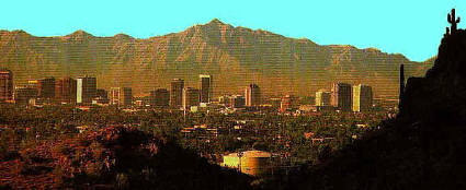
The Estrellas. It is hard to believe that this range is among the most remote and least visited in Arizona - and that is fine with me! Only in the Estrellas could you have an Old Spanish Gold mine and arquiological site a few miles from Downtown Phoenix.
The bajadas, or the low rolling plateaus, are still relatively undistrubed in the Estrella region. A wide variety of cacti, such as cholla, ocatillo and the towering saguaro, share the landscape with creosote bush and isolated clusters of paloverde and mesquite trees. Wildlife is abundant, or at least it was in the 50s when I was young. Birds of all types, jackrabbits, and ground squirrels were plentiful. Deer, skunk, javalina, cayote and badger sign were common. And there were plenty of snakes too. In fact some of the biggest and meanest rattlers in Arizona have an Estrella address on their business cards. Near Sevenmile Mountain I saw the only bobcat I've seen in the wild, as well as the largest dessert tortoise. Mountain bighorn sheep still inhabit the high slopes of the range, but certainly not in the numbers they used to. An early traveller, Manje, reported seeing a pile of more than 100,000 horns from these animals stacked at a village at the north end of the Estrellas. Later, I will say a few more things about Manje, a man that surely deserves consideration along with Frei(?) Marcos de Niza as Arizona's first troublemaker. Anyway, regarding the quantity of horns, let it be said that if Manje had lived in the twentieth century, he would gotten a job counting votes for LBJ.
More important than the mountains and bajadas are the region's rivers. Although the Salt is larger, the Pimas and their probable ancestors, the Hohokam, seemed to prefer the smaller and more manageable Gila. ??? The Gila, flowing across the plains of the Sonoran Desert to the east of the Estrellas, on its way to meet the larger Salt at the northern end of the mountains, was joined by the Santa Cruz, they were enough to insure an adequate food supply for the Pimas.
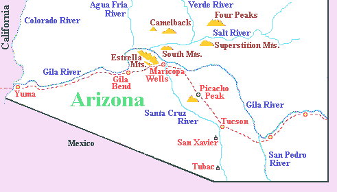
Map of Maricopa Wells and Sierra Estrella region
For the purposes of this article I would like to define Maricopa as the area surrounding the middle Gila River, from it confluence with the Salt River south and east to the Casa Grande ruins. And no narrative /account of this region can advance very far without saying a word or two about the Gila Trail, a feature almost as important to Maricopa as the river itself. Once again, to avoid misunderstandings and scholarly rebukes, I would like to say that I am aware that the term is a misnomer (?) - there was no single Gila Trail and that different and possibly more accurate names could be applied to distinct portions of it - but I couldn't care less.
Because of the water, the flat terrain and the plentiful supplies available from the usually friendly indians, the Maricopa region on the Gila River became an important stop on the trail to California. Starting with Col. Anza, the energetic army commander from the Tubac garrison who lead the first expedition to the West Coast and colonize San Francisco, almost all travellers would pass stop, rest, and resupply at Pima-Maricopa villages. The padres and spanish explorers were soon followed by Forty-Niners, freight wagons, American military expeditions, stagecoaches, settlers and telegraph lines - and all this while Phoenix was but an unnamed mound of ruins on the north side of the Salt River.
When the Sierra Estrellas were given their present name, and by whom, is a mystery. Although Padre Kino (was it Kino, Annerino says Garces ?????) called the San Jose de Cumar, thankfully it didn't stick. A by no means exhaustive search produces a relatively late 1854 first reference to the mountains by their present name in the journals of A.B. Grey, who has doing exploratory and surveying work for the US government. A quick survey of historical maps shows the first map to specifically identifying the Sierra Estrellas as such was the XXXXX map published in 1111. Although both writers and cartographers mentioned are from the American period, the name can probably be traced to a Mexican source.
In 19th century journals it is common to find the Estrellas referred to as the Maricopa Mountains, a title now bestowed on a similar sized range running parallel 15 (?) miles to the west. This is not surprising in view of the fact that the basic geography of the region was not fully understood until the late 1870s. The Sierra Estrellas were first charted on Kino's "Passo por Tierra" map of 1701, being represented by a mountain symbol west of the union of the Santa Cruz and Rio de Hila (the Gila). Thus we find such maps as a 1878 one showing a single huge Sierra de La Estrella mountain range occupying the entire Gila Bend area instead of the three separate ranges actually existing, or the 18?? map in which the Sierra Estrellas are shown lying in an east-west direction below the northern curve of the Gila River. Somebody must have had a compass problem. My favorite map is the 18?? map of XXXXX that not only shows the Salt and Gila River valleys and surrounding mountains, including the Sierra Estrellas, but also clearly marks the location of one of the "Ancient City of Cibola".
When the first Spanish explorers arrived, the lands from south of the Casa Grande ruins up to and beyond the mouth of the Salt River were already called home by the Gila River Pimas, a sub-group of the Pima tribe whose territory extended down to Sonora. Sometime around the beginning of the 19th century, a smaller group that became known as the Maricopas, moved in to the area near the confluence with the Salt River. This was also the land of the Pima and Maricopa indians, whose settlements dotted the Gila and San Pedro rivers. These tribes were more often than not friendly to the Spanish and were frequently counted upon as allies by the white man in his struggle with a common enemy, the Apaches. These two tribes, although belong to distinct tribal and linguistic groups, have lived and worked together in relative harmony. This is to a certain extent unique, because, contrary to popular concepts now in vogue, society in Pre-colombian America was not exactly peaceful. A reading of Pima memoirs (?) and calendar sticks tells us that life could be hard and death was often sudden. However, both tribes shared not only the fertile fields along the river, but also a common life style and outlook. Just for the record I would like to add that there has been quite a bit of scholarly debate as to the origins and patterns of settlement of both tribes, but a reading of anthropological papers on this question is not for the faint of heart.
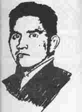
Ira Hayes. Pima World War II hero. Imortalized on Iwo Jima Marine Corps statue in Washington DC. and in the most famous war picture of all time.
The Pima and Maricopas were not just quiet farmers, but also very respectable warriors when the need arose, a necessary ability to hold the only area in the region with dependable water and fertile soil. The Pima, called by one explorer the only military alternative to the Apaches, were by all accounts an effective military force and a advisory to be reckoned with. To protect their fields, a standing fighting force was formed, as well as a system of sentinels and messengers. The Pima fighting tradition did not end with the frontier. The first Arizonan to die during World War I was Mathew Rivers a Pima. It is sufficient to say that one of the bronze figures on the Iwo Jima memorial is that of Ira Hayes, born in Sacaton on the Gila Indian reservation. One wonders what Antonio Azul, a much respected Pima Chief in the second half of the Nineteenth century, would have said if he were told that Pima boys would be fighting and dying in such places as France, Africa, Vietnam and many small islands of the Pacific?
To the Indians, the Sierra Estrellas were a shield, protecting their western flank from incursions by often hostile Colorado River tribes, and allowing them to concentrate their defenses in other areas, most commonly to the Southeast approached to their territory. being the largest and most rugged mountains in the vicinity and, at the same time, because of that ruggedness and lack of water, being far enough removed from everyday activities, the Sierra Estrellas acquired a somewhat mystical status to the Indians.
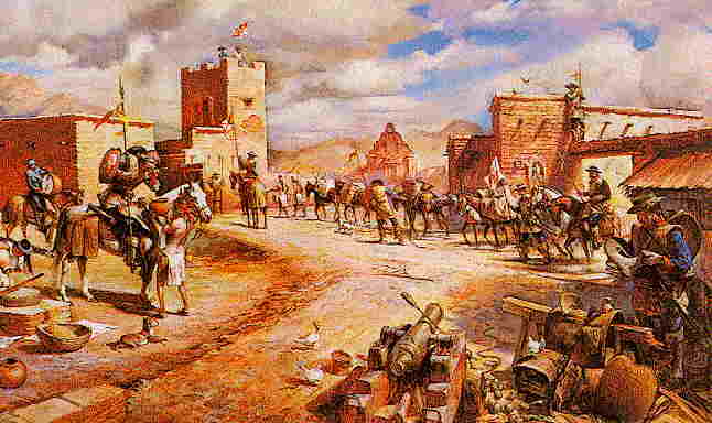
Tubac, Arizona. First ond oldest European site in Arizona. Was the starting point for most expediations going north. Now in ruins.
For one and three quarter centuries the Maricopa area marked the northern border of Spanish influence in what is now Arizona. However, in the final years of the 17th century, almost three hundred years ago, a remarkable man named appeared who was to initiate the radical changes to come in the what is now Sonora and southern Arizona. Eusebio Kino was not only a german born Jesuit priest, but also a great explorer, cartographer and writer. By the beginning of the 18th century, Kino and other Jesuits had built a string of missions in what was called Pimer�a Alta. Although the northernmost mission in Arizona was near Tucson, the Spanish Padres and explorers were well acquainted with the Gila River region from the Casa Grande ruins to where the Salt and Gila Rivers meet. Kino himself made no less than six visits to this area. ????? or over two centuries the Gila River marked the northern border of Spanish influence in what is now Arizona.
Kino mentions at least 12 settlements in this area, inhabited by approximately five thousand indians. While no missions were build here, as were farther south, the Spaniards established at least 2 rancherias for trading and ranching. By the time Padre Garces visited the area, almost seventy years latter, settlement patterns had changed somewhat but life was much the same. For the most part, the Maricopa area continued to be what it had been for centuries, a good stopping point on the trail to the Pacific coast.
On September 30, 1698 Kino made what is the first specific documented reference to the Sierra Estrellas. After visiting the Pima villages along the Gila, writing in his journal that he "was anxious to ascend a mountain which was in site, to see if from its summit could be seen the lands and villages round about, and if it were possible to decry the very sea coast and the best road to go out to view the disemboguement of the Rio Grande [Gila] into the Sea of California." Kino, a great cartographer always on the lookout for new geographical information, hoped to see the mouth of the Gila River flowing into the Pacific. There is no record if he actually did climb to the crest of the Estrellas, and it is just as well that he didn't because it would have not only been extremely laborious but also futile - the nearest sea is over 250 (?) miles away. However, Kino did learn that the Gila flowed northward in a great curve around the mountains and then continued in south-western direction to the coast. It must be remembered at that date the geography of the southwest was pretty much unknown at that time, for it was commonly supposed that the Gila and Colorado Rivers flowed separately into the Pacific, and California was an island.
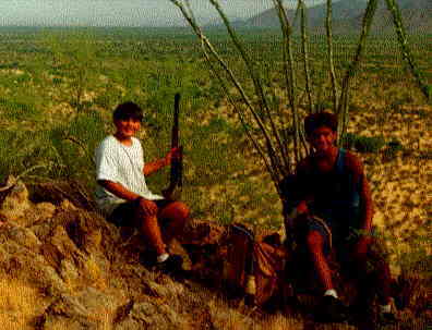 The Estrella region is rough!! This picture is a reminder how bad it can be. Danny, with gun, and John R., holding small black dog in his lap. This one one of worst days in my life. We ran out of water in the Estrellas... The dog did not survive this trip to the Old Mine
The independence of Mexico from Spain in 1822 (?) did not significantly alter life in the Maricopa area. Although visited by several Mexican expeditions, such as that of Romero in 9999 and ocasionally by American trappers or explorers, the Pimas continued to live in a manner essentially the same as recorded by Kino and Garces generations earilier. But, as the middle of the nineteenth century approached, big changes were about to occur.
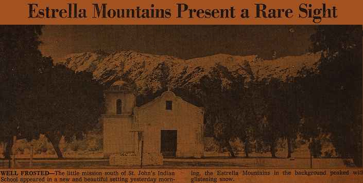
Rare picture of Estrellas with snow. I found this at a garage sale, and it put me back 10 cents. I believe it was originally from the Az Republic.
For more information on the Sierra Estrellas check out these pages here:
The Story of the Estrellas
Maricopa Wells and the stage route
Old Maps of Region
The Old Spanish Mine
The Patio - the most historic area of Estrellas
![]()
![]()
![]()
![]()
![]()
![]()
![]()
![]()
![]()
![]()
![]()
![]()
![]()
![]()
![]()
![]()
![]()
![]()
![]()
![]()
![]()
![]()
![]()
![]()
![]()
![]()
![]()
![]()
![]()
![]()
![]()