Main Chart of the Sierra Estrella Mountains and Old Maricopa area
First of all, let me say that it is not easy to identify and confirm any names relating to the Estrellas. The problem is that most places (peaks, valleys, ravines, passes, washes, ridges, canyons, etc...) have no official names on maps, even those that are in common use in communities around the area. Many of the names I learned as a child are not found anywhere. Even the names that are used are often wrong. Actually only two or three places have "good" names, but these are often wrongly attributed to other points. Only Monetezuma Head and Monument Hill are usually identified correctly on maps and in popular usage, except that few people have actually seen Montezuma's Head and Monument Hill is only noteworthy because it is "ground zero" for all legal geographic renderings in Arizona. Even so, it was formally known as Boundary Knoll. Perhaps the worst offenders are Butterfly Peak (Correct on USGS maps, but almost always situated incorrectly in popular usage). The Arizona Republic is a major ofender here. Let me get this straight. The big, tall peak that looks like a bat - yes, the tallest one in the Phoenix Metro area - is not Butterfly Peak. OK! Also, Montezuma Sleeping is not realy a peak either, or it shouldn't be. The way I learned it is that Montezuma Sleeping is the outline of the old Aztec warrior, and goes from the South end of the range near Montezuma Peak up to the Montezuma Sleeping point, for about 10 miles. That is what the diaries from the 1840s and 50s say, based on old legends. And on it goes...
I tell you nothing is easy when it comes to names in the Estrellas. Below is a list of the names I have run accross in the last 50 years. Most are "good" names and have been collaborated by third parties. Some I have heard nowhere else. There are probably other names I don't know that are in local use. Take the example of "Hummingbird Canyon". There is a Hummingbird canyon, named by the Pimas. A lady at St John's pointed it out to me, as she did some other points. So I put it down on the map, beliving her to be correct. Why not? Another case is Quartz Peak, up in the northern area. I know there is a Quartz Peak, I even have pictures of it. Now the problem is placing it on a map. I even asked officials at the Estrella Park and they said they had heard of it, but didn't know exactly which peak it was. The same is true of Beardache Hill. I know it is high point on the northern part of the Estrellas, but not exactly sure which one. It may be the same as Monument Mountain or possibly the one next to it. .
I have collected quite a few maps and charts of the Sierra Estrella region, mostly trying to identify location names.
Based upon official US Geological Survey documents I created the map below (map0001a). On this chart I will attempt to identify names and locations of all places cited in old documents and/or on this site. I will label each place by category, using a letter/number combination as follows: (M) Main geographic features, such as ranges, peaks, etc; (N) Secondary geographic features, such as valleys and ridges; [C] Cities and communities; [T] Treasure sites; [P] petroglyph sites; [R] Rivers and washes; [B] Battle and outlaw related; [C] Mining claims and prospecting; [E] Other points of interest
[M] Main geographic features
- M-1. Montezuma Peak
- M-2. Montezuma Head
- M-3. Butterfly Peak
- M-4. Montezuma Sleeping
- M-5. Hayes Peak
- M-6. Montezuma Point (and Lookout Point)
- M-7. SevenMile Mountain
- M-8. Married Native American Woman Breast Nipple Peak
- M-9. Monument Hill
- M-10 Beardache Mountain
- M-12. Quartz Peak
[N] Secondary geographic features
- N-1. Hummingbird Canyon
- N-2. Circus Ridge
- N-3. Komatke Ridge
- N-4. Butterfly Canyon
- N-5. Butterfly Ridge
- N-6. Patio Area
- N-7. Wild Horse Pass
- N-8. Montezuma Plateau
- N-9. Maricopa Canyon (behind Co-op)
- N-11. Estrella Foothills
- N-12. Estrella Pass
- N-13. Santa Cruz Ridge
- N-14. Shadow Canyon
- N-15. BigHorn Canyon
- N-16. DeadDog Ridge
- N-17. Coyote Canyon
- N-18. White Butte
- N-21. Quarry Point
- N-22. Old Jeep Road Pass
- N-23. Rainbow Point
- N-24. North Tail Point (SevenMile Mountain)
- N-25. Lizard Head (Southern point of Sevenmile Mntn.
- N-26. Wilpauldee Peak (SevenMile Mntn)
- N-31. Pima Butte, Komate Butte, M Mountain, Sacate Butte(?)
- N-32. Lone Butte
- N-51. Casa Grande Ruins (here for reference purposes)
- N-61. South Mountains, formerly Salt River Mountains
- N-62. Telegraph pass
- N-63. Pima Canyon (East side South Mnts.)
[C] Cities and communities
- C-1. Maricopa
- C-2. Komatke (San Bartolome del Comac, San Andres de Coate?)
- C-3. Gila Crossing
- C-4. St Johns
- C-5. Santa Cruz Village
- C-6. Laveen
- C-7. Maricopa Wells (Santa Tereza, Lagunas del Hospital)
- C-8. Sacate
- C-11. Liberty
- C-12. Goodyear
- C-13. Rainbow Valley
- C-14. Avondale
- C-15. Kyrene
- C-16. Casa Blanca
- C-21. Sacaton (Encarnacion, Tudacson, Sudacson, Sutaquison, Sudaisson, Tucsonimo
- C-22. Sacaton Station
- C-23. Happy Camp
- C-24. Tank or Maricopa Tank
- C-25. Hidden Valley
- C-31. Desert Station
- C-32. Morgan's Ferry
- C-41. Sweetwater (Neida Station?)
- C-42. Heaton / Maricopaville
,
- C-43. Enid / Montezuma?
,
- C-44. Estrella
,
- C-45. Bosque (RR station, abandoned and gone)
[T] Treasure sites
- T-01. Montezuma Head Treasure (Campoy/Ortega)
- T-02. Aztec Montezuma Treasure
- T-03. Old Wheel Pioneer buried treasure (1849 / Montezuma Head)
- T-04. Don Joaquim Gold Mine
- T-06. Lost Queen mine
- T-07. Butterfly
- T-08. Gold Ledge Mine (Frenchy/Coyote, in North Estrellas)
- T-10. "Grill face" gold cache
- T-11. Outlaw route buried gold
[W] Washes, rivers and wells
- W-1. Gila River, also spelled Hila and Xila
- W-3. Santa Cruz River
- W-4. Salt River, also Rio Salado and Rio Salinas
- W-6. Vekol Wash
- W-7. Gorgett Wash
- W-11. Waterman Wash
- W-12. Estrella Wash
- W-13. Camping Wash
- W-14. 7mile Wash
[W] Roads, routes, trails
- R-1. Cooks Wagon trail, Old Emigrant trail, Butterfield Stage route, Gila trail
- R-2. Jornada de las Estrellas, Forty Mile desert route
- R-5. Toll road north to Presott
- R-6. Maricopa Wells - Wickenburg stage route
- R-8. Estrella pass road
- R-9. Old Mine road
- R-11. Old Jeep Road
- R-15. Powerline Road
[B] Battle and outlaw related
- B-1. Pima Butte battle (Arizona's bloodiest battle
- B-2. Old Wheel Massacre site, near Montezuma Head
- B-3. Outlaw Point, near Laveen
[E] Other points of interest
- E-1. PIR Racetrack
- E-2. Peralta Marker
- E-5. Malukiam UFO space port
- E-7. Naval tracking site and landing strip
- E-8. Glider field
- E-11. Luthansa Training Airfield
Other Features of Interest (not individualized)
- C - Mining claims and prospecting
- P - Petroglyph sites
- X - Plane crash sites
- A - Antenna towers
Location maps
Following are three maps used to place and identify the points
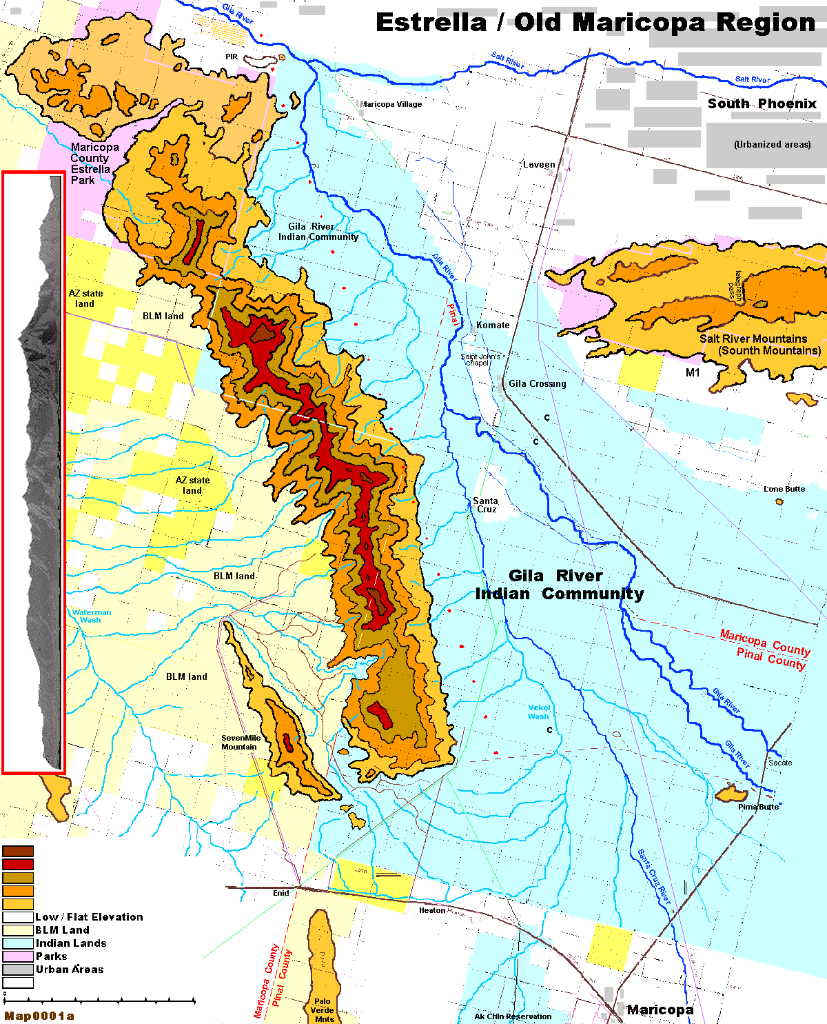
Map0001a. The figure above is my own rendition of the area, based on a USGS map. I have labeled all known points listed above on the map.
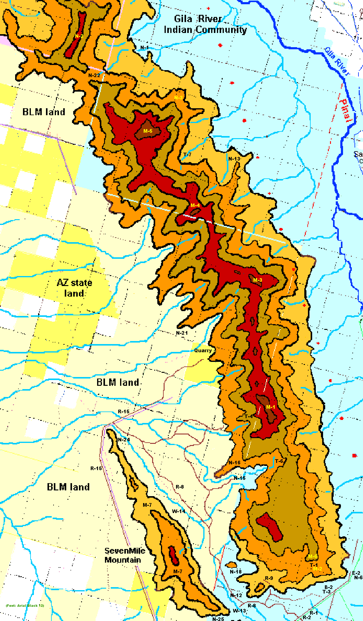
Map0001b. Detail of the southern part of the Estrellas, based on map above.
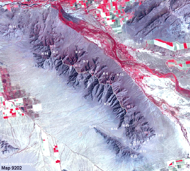
MAp9202. The above represents the same area, but based on a satellite photo.
 This page is under construction!
Please come back later.


